Analysis on influencing factors of runoff evolution in typical watershed of the upper Huaihe River: Illustrated by the case of the Bailianya basin
-
摘要:
研究白莲崖流域径流变化特征及其与环境因子的关系,可为区域防洪减灾、工农业生产及水土资源的合理利用提供决策依据。利用Mann-Kendall检验、Yamamoto信噪比及交叉小波变换等方法对白莲崖流域1970—2009年径流变化特征及其与环境因子的关联性进行了分析。结果表明:径流年内分配不均,主要集中在6、7月份,在1983年和2004—2005年径流发生2次突变;径流存在0.5~3年的小周期变化现象;径流和降水在1986—1996年1~2年以及1998—2002年2.5~4年周期上具有强关联性,径流对降水响应较快,大多数高能量时频域中表现为同相位关系;径流和气温的相互影响主要集中在1988—2000年1~3.8年周期上,气温的相位优先于径流,径流对气温的响应具有时滞性;研究区内径流总体上呈减少趋势,主要下垫面因素为森林面积的增加和农田面积的减少。随着气候和下垫面状况的变化,白莲崖径流年际年内都发生了显著变化,与不同气候因子表现出不同关联特性。
Abstract:BackgroundFor last 30 years, the global temperature rose with the influence of the precipitation spatial distribution pattern. Economic and social development, the spatial and temporal of the runoff varied significantly, and its evolution also showed a strong randomness at the same time. The Bailianya river basin is located in Dabie mountain, which is the watershed between Yangtze River basin and Huaihe River basin. The study on the characteristics of runoff change in the Bailianya river basin and its relationship with environmental factors may provide decision-making basis for regional flood control and disaster reduction, industrial and agricultural production and rational utilization of soil and water resources.
MethodsThe variation characteristics of the runoff of Bailianya basin and its correlation with major environmental factors from 1970 to 2009 was detected through the Mann-Kendall test, Yamamoto method of signal-to-noise ratio and the cross wavelet transform analysis. The relationship between time series of environmental factors and runoff in different frequency domain was revealed using cross wavelet analysis. The response of runoff to the change of underlying surface elements was also clarified based on the analysis of remote sensing images in 3 stages. The coupled oscillations of runoff time series, precipitation and air temperature in Bailianya river basin were investigated from the frequency domain, which reflected the correlation between runoff and climatic factors on different time scales.
Results1) The distribution of runoff was uneven during the year and mainly concentrated in June and July. The 2 abrupt changes of runoff occurred in 1983 and 2004-2005. Runoff demonstrated a small cycle of 0.5-3 year(s). 2) There was strong correlation between runoff and precipitation at a cycle of 1-2 year(s) in 1986-1996 and at a cycle of 2.5-4 year(s) in 1998-2002. Runoff responded to precipitation fast with most high energy time-frequency domain characterized by phase relationship. 3) Interactions between the runoff and the temperature were mainly concentrated in a cycle of 1-3.8 year(s) in 1988-2000. The phase of temperature was prior to that of the runoff. Runoff responded to temperature with a time lag. The change of underlying surface elements strongly changed the nature of the surface of the basin, and had certain influence on the hydrological cycle at different time and space scales, causing the change of runoff and confluence conditions in the basin, and thus changing the hydrological process of the basin. Forest and farmland were the main underlying factors that caused runoff change in Bailianya basin, and had obvious influence on runoff change. With the increase of forest area and the decrease of farmland area, runoff showed a decreasing trend.
ConclusionsWith the change of climate variation and underlying surface condition, the runoff of Bailianya river basin varies significantly in the interannual period and within a year, showing different correlation characteristics with different environmental factors. Precipitation in Bailianya river basin is the direct factor of the runoff change. The response of the runoff to air temperature is of time delay. Compared with forest, farmland is weak in rainfall interception and infiltration, and the conversion of farmland to forest will lead to the relative reduction of runoff.
-
Keywords:
- runoff /
- environment factors /
- cross wavelet transform
-
在气候因素、流域下垫面状况及人类活动的相互作用下,河川径流序列是一个非线性、弱相依且非常复杂的动态系统[1]。近30年来,受降水空间分配格局、全球气温上升、经济社会发展等的影响[2-4],河川径流发生了显著的时空变化,其演变过程既存在确定性的规律,同时也表现出强烈的随机性,对流域洪水涨落、水土流失现状及河流生态系统产生直接影响[5]。自产流至汇流的开放式动态过程中,河川径流与外界进行着连续的物质能量交换,易受外界规律或不规律的干扰作用,从而表现出从日、月到千万年的多尺度径流变化现象[6]。在多时间尺度上,揭示流域降水、气温等环境因子与径流的关联作用,在不同的时频域上分析各种径流影响因素对径流的作用机制,研究各因素变化对径流的影响非常重要[7]。目前,多时间尺度分析主要用于诊断单一流域径流序列或单一气候要素序列的变化特征[8]。研究流域径流变化特征及其与环境因子的关系,可为区域防洪减灾、工农业生产及水土资源的合理利用提供决策依据。
白莲崖流域是淮河流域上游的重要子流域之一,受到气候变化和人类活动的影响,流域内水资源发生了显著变化。笔者从频率域上考察白莲崖流域径流时间序列与降水、气温序列的耦合震荡,研究不同时间尺度上径流与气候因素的关联特征,且通过对流域下垫面要素变化的定量分析,可以明确引起径流变化的主要下垫面驱动要素。
1. 研究区概况
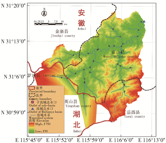
白莲崖流域位于大别山腹地、安徽省与湖北省交界处(图 1),流域主体位于安徽省霍山县境内(E 115°45′~116°13′,N 30°52′~31°20′),是淮河流域西南片区子流域的重要组成部分,总面积900多km2。大别山地势沿西南向东北方向下降,平均海拔约734 m,相对高差达1 600 m左右。气候属亚热带湿润季风气候区,年平均气温15 ℃,年平均降雨量1 400 mm,植被类型以常绿落叶阔叶混交林为主。
2. 材料与方法
2.1 数据来源及处理
所用径流和气象因素中的降雨数据为白莲崖流域总出水口处水文站的1970—2009年的逐月实测数据;气象因素中的日最高气温和日最低气温由美国国家环境预报中心(National Centers for Environmental Prediction, NCEP)提供,时间范围1970—2009年;该数据集是气候再分析系统(climate forecast system reanalysis, CFSR)的主要产品,CFSR作为全球尺度、高分辨率、大气-海洋-陆地表面-冰雪的耦合系统为大气参数提供了最佳估计,在此基础上由极差均值法[9]生成日平均气温数据;流域下垫面数据由美国地质勘探局(United States Geological Survey, 以下简称USGS)提供的1987、1999和2009年3期Landsat 5 TM影像经过经典的最大似然分类法得到,总体分类精度约为85%,满足研究需要。
2.2 研究方法
2.2.1 径流年际变化特征分析法
Mann-Kendall(以下简称MK)是一种无分布趋势检验法,该方法无需样本遵从正态分布,适于水文、气象等时间序列的趋势检验分析[10]。Yamamoto方法是从气候信息与气候噪声2部分来讨论突变问题的[11],原理为对于时间序列x,设置某一时刻为基准点,将时间序列分为2段子序列x1和x2,记其均值为x1和x2, 标准差为s1和s2,则定义信噪比为RSN=|x1-x2|/(s1+s2)。给定一定显著水平α0,确定临界统计量tα,当RSN$\sqrt L $>tα且RSNi>1,则可判定突变发生,式中RSNi为i时刻的RSN值,L为子序列长度。
2.2.2 径流年代及年内分配特征分析法
采用径流集中度(runoff concentration degree, RCD)与集中期(runoff concentration period, RCP)为主要指标衡量径流年代及年内分配特征。径流集中度将月径流量作为向量,其大小即为向量的模;所处的月份即为向量的方向,用圆周方位来表示;各月径流向量的和向量模与年径流量的比值为年径流集中度,方向为年径流集中期。集中度能够客观反映径流的年内分配特性,当径流量集中在某一月内时,RCD达极大值1;若每个月的径流量都相等,则RCD达极小值0,表明全年的径流量匀称分布于各月份。RCP则客观地反映了一年中最大径流量出现的时间[12]。RCD与RCP为量纲一的量,计算公式如下:
$$ \mathrm{RCD}_{\text {year }}=\sqrt{R_{x}^{2}+R_{y}^{2} / R_{\text {year }}}; $$ (1) $$ \mathrm{RCP}_{\text {year }}=\arctan \left(R_{x} / R_{y}\right); $$ (2) $$ R_{x}=\sum\limits_{i=1}^{12} r_{i} \sin \theta_{i}; $$ (3) $$ R_{y}=\sum\limits_{i=1}^{12} r_{i} \cos \theta_{i}。 $$ (4) 式中:RCDyear为年径流集中度,量纲一;RCPyear为年径流集中期,量纲一;Ryear为年径流量,m3/s;Rx、Ry分别为年和向量的水平、垂直分量,m3/s;ri为第i月的径流量,m3/s;θi为径流第i月的矢量角度,(°)。
2.2.3 小波交叉分析法RCD
传统的小波变换仅能揭示单一时间序列在不同时频域上的变化规律,而交叉小波变换是将交叉谱分析与小波变换相结合的一种新的信号分析技术。设WnX(s)、WnY(s)分别为2个时间序列X和Y的交叉小波变换,定义交叉小波谱为WnXY(s)=WnX(s)WnY(s),则功率谱密度为|WnXY(s)|,其值越大,二者相关越显著。对连续交叉小波功率谱的检验方法为:假定时间序列X和Y的期望谱为红色噪音谱PkX和PkY,则交叉小波功率谱分布有如下方程式[5]:
$$ \frac{\left|W_{n}^{X}(s) W_{n}^{Y}(s)\right|}{\sigma_{X} \sigma_{Y}}=\frac{Z_{V}(P)}{V} \sqrt{P_{k}^{X} P_{k}^{Y}}。 $$ (5) 式中:σX、σY分别为时间序列X、Y的标准差,V为自由度,ZV(P)为置信度。计算红色噪音功率谱的95%的置信度上界,当式(4)左端超过置信度上界,则认红色噪音标准谱的检验,两者相关显著。
3. 结果与分析
3.1 径流年际变化特征
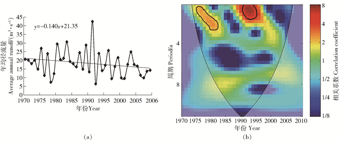
白莲崖流域1970—2009年年均径流量呈降低趋势(图 2(a)),年均减少速率约为0.15 m3/s。研究时段内白莲崖流域径流变化可分为3个主要阶段:第1阶段为1970—1975年,此期间流域受外界干扰较小,径流年际变化幅度较小;第2阶段1975—1991年,随着当地生产力的解放,工农业活动逐渐剧烈、农田水利工程建设的完善等因素的影响,流域径流亦出现了较大的振幅变化,年际变化幅度多小于20 m3/s;1990—1991年,仅1年时间,径流变化幅度超过35 m3/s;究其原因,1991年5月21日至7月15日的56 d时间内,淮河流域出现了多次强降水过程,遭受了自1954年以来最大的一次洪涝灾害,这次事件主要由梅雨造成,1991年淮河以南5月18日入梅,较常年提早1个月,7月15日出梅,梅雨期长达58 d,比正常年份长了1个月[13];因而1991年前后,白莲崖流域年均径流量出现异常波动现象,1991年时,年均径流量达到峰值42.55 m3/s。第3阶段1992—2009年,净化变化幅度恢复至第2阶段1975—1990年振动幅度。
![]() 图 2 白莲崖流域年际径流量变化(a)及周期变化(b)图b中粗线为95%置信度红噪声检验,细线为小波影响锥,箭头表示相位,下同。Figure 2. Annual runoff change (a) of Bailianya basin and periodic variation (b)The thick line in Fig.b is the red noise test of 95% confidence degree, the thin line is the wavelet influence cone, and the arrow is the phase. The same below.
图 2 白莲崖流域年际径流量变化(a)及周期变化(b)图b中粗线为95%置信度红噪声检验,细线为小波影响锥,箭头表示相位,下同。Figure 2. Annual runoff change (a) of Bailianya basin and periodic variation (b)The thick line in Fig.b is the red noise test of 95% confidence degree, the thin line is the wavelet influence cone, and the arrow is the phase. The same below.对年径流量序列进行连续小波变换(图 2(b)),径流序列呈0.5~3年的小周期变化,1975—1983年,0.5~3年的周期变化显著,1992—1997年,0.5~2年的周期变化显著。王振龙等[14]对淮河干流的径流演变特征进行了分析,认为淮河干流年均径流量呈减少趋势,且存在以2年为主的周期规律,这与本文的分析是相符的。
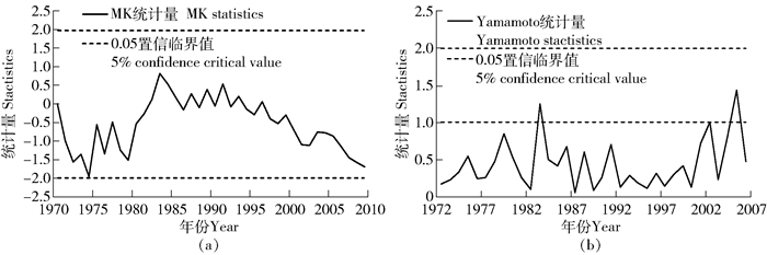
对白莲崖年均径流量序列进行MK趋势检验(图 3(a)),1970—2009年,年均径流量的变化均未通过置信水平为0.05的趋势检验,即变化趋势不显著。1970—1982年,MK统计量为负值,年均径流量呈不显著减少趋势;1983—1994年,MK统计量为正值,年均径流量呈不显著增加趋势;1995年后,年均径流量呈不显著减少趋势。为进一步明确年均径流量的突变时期,笔者采用Yamamoto信噪比法对年均径流序列进行突变检验(图 3(b)),在给定0.05(统计量值为1)的置信水平下,白莲崖流域在1983年和2004—2005年2个时期内径流量发生突变。根据霍山县志记载,该县农田水利基本建设投资在50年代末期至1984年,累计投资1 366万元。其中60年代末至1978年,建机、电排灌站63处,装机79台2 937 kW,受益面积25 km2。新建小水库57个,总库容1 532万m3,灌溉面积21.33 km2。1978—1983年,新增机、电排灌站11处,装机35台1 172 kW。这些农田水利、社会生产等人为活动改变了自然条件下的地表状况,对流域径流时空分布和演变规律产生了重要影响[15]。1983年的径流量突变期可视为天然径流量与被气候、人类活动等扰动径流量的分界线;2004—2005年径流量的突变,则与我国自1999年以来实施的退耕还林工程密切相关。退耕还林工程实施后,白莲崖流域的林地面积增加,耕地减少,致使90年代末至21世纪初流域径流量的减少。
![]() 图 3 白莲崖流域MK检验和Yamamoto突变检验Figure 3. MK test and Yamamoto abrupt change test in Bailianya basin
图 3 白莲崖流域MK检验和Yamamoto突变检验Figure 3. MK test and Yamamoto abrupt change test in Bailianya basin3.2 径流年代及年内分配特征
由表 1可知,白莲崖流域年内径流量分布不均。径流量的不均匀系数高的时期,集中度也较高,二者具有较好的同步性。就径流集中度而言,2000—2009年径流集中度最小,而90年代径流集中度最大。除90年代小幅回升外,径流集中度和不均匀系数总体呈降低趋势,即径流量的分配向均衡化发展。就径流年内集中期而言,白莲崖流域径流集中期出现在6、7月。80年代径流集中期出现在6月末,相对多年平均提前19 d,其他时段径流集中期为7月底,与多年平均值基本一致。从径流年内变化幅度看,80年代的变化幅度最低,仅为74.1%,其次为70年代,84.6%,90年代和2000—2009年均较高,整体而论,径流的年内变化幅度存在升高趋势。
表 1 白莲崖流域径流年内分配统计特征Table 1. Distribution statistic characteristics of Bailianya basin runoff within the year时段
Period不均匀系数
Uniformity coefficient/%集中度
RCD/%集中期(RCP) 变化幅度
Variation/%和向量方向
Direction of sum vector/(°)最大径流出现日期
Maximum runoff date/(Month Day)1970—1979 65.0 45.8 221.7 7月27日July 27th 84.6 1980—1989 63.3 44.1 194.5 6月30日June 30th 74.1 1990—1999 66.7 46.1 221.4 7月26日July 26th 187.1 2000—2009 61.7 41.8 217.3 7月22日July 22nd 221.7 多年平均Multi-annual average 64.2 44.5 213.7 7月19日July 19th 8.9 Notes: RCD stands for runoff concentration degree, and RCP stands for runoff concentration period. 3.3 径流与主要气象因素的多时间尺度关联性
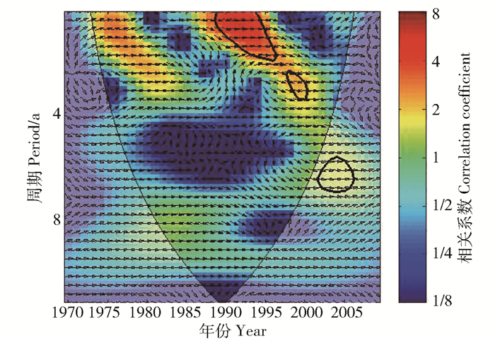
1) 降水因素。降水是径流的直接补给源,其强度、持续时间及其时空分布对径流格局的形成具有决定性作用。白莲崖流域降水—径流的交叉小波分析揭示了在不同时频域内,降水与径流的内在联系。图 4表明降水和径流的交叉小波功率谱能量主要集中在1973—1984年1~3年、1986—1996年1~2年以及1998—2002年2.5~4年周期上,其中1973—1984年1~3年周期上的功率谱高能量区虽表现出径流-降水较强的关联性,但未通过红噪声检验,而后2个周期中,径流-降水表现出极强的关联性,通过了红噪声检验。2002—2007年6~7年周期上存在通过红噪声检验的径流-降水高能量区,但因其位于小波影响锥外,是小波交叉分析自身的边缘效应所引致的干扰,因此不予考虑。1973—2004年的4~16年周期上,径流-降水关联性较弱,表明白莲崖流域径流-降水高能量区在小于4年周期的尺度上的关联性显著。注意到,降水-径流在大多数高能量时频域中表现为同相位关系,表明降水是径流变化的直接影响因素,径流对降水响应较快,基本呈同步变化。降水对径流高频域上的作用对应地表径流对降水的直接响应,而在低频域上的影响则是壤中流和地下径流滞后放大引起的。
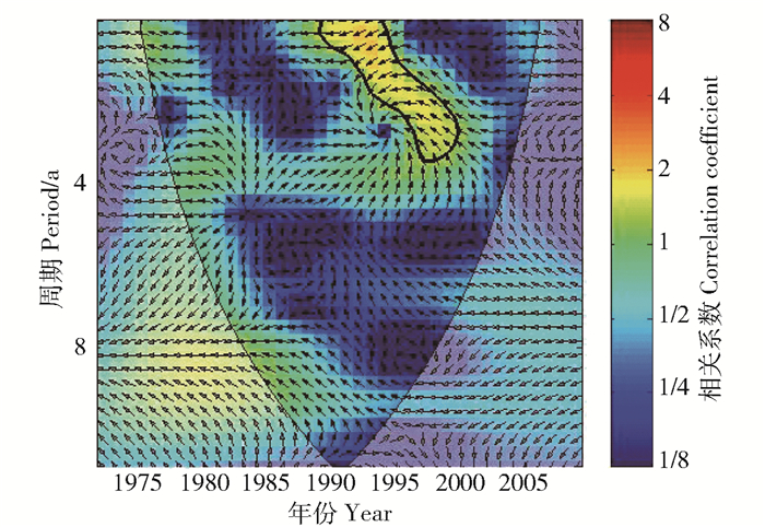
2) 气温因素。对白莲崖流域径流和气温序列进行交叉小波分析(图 5),其径流-气温的相互影响主要集中在1988—2000年1~3.8年周期上,在其他时频域中相互影响不显著。淮河流域70、80年代的年均气温基本为下降趋势,进入90年代后,气温开始上升,白莲崖流域径流对于这次气温的冷暖交替现象响应较快。同时由该时期内的径流-气温位相关系可知,气温与径流存在反相位关系,气温优先径流3/4π~5/4π个周期,表明径流对于气温的响应具有时滞性,气温上升时,径流呈现减少的趋势。白莲崖流域径流-气温高能量区在小于4年周期的尺度上的关联性显著,这与前述径流-降水交叉小波功率谱的结果是一致的。纵览图 4和图 5,气温对白莲崖流域径流的影响明显弱于降水;气温主要是通过与其他气象因子的综合作用来间接影响径流的。
3.4 流域下垫面要素对径流的影响
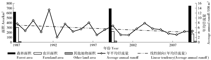
下垫面要素的变化强烈地改变了流域地表的性质,对不同时间和空间尺度的水文循环会产生一定的影响,引起流域产汇流条件的变化,进而改变了流域水文过程,是洪涝灾害频繁发生的重要原因之一。经1987、1999及2009年3期白莲崖流域的专题绘图仪(thematic mapper,简称TM)影像解译可知,森林和农田总面积分别占流域总面积的98.4%、97.2%及97.3%,水体面积变化不大。显然其他下垫面要素由于面积过于狭小,不会对径流的变化产生重要作用。由图 6线性倾向趋势线可知,22年间径流量和农田面积呈减少趋势,森林面积呈增加趋势。1987—1999年正值我国“七五”与“八五”计划时期,封山育林和封山护林行动得到迅速发展,森林得到有效保护与恢复。1999—2009年,霍山县大力实施退耕还林项目建设,成为了皖西退耕还林的主要战场之一。森林1987—1999年期间由627.59 km2增加到695.60 km2,到2009年增加到751.86 km2;农田1987—1999年期间由306.78 km2减少到226.08 km2,到2009年减少到172.55 km2。森林通过枝叶的截留作用以及利用凋落物层和林木根系的涵蓄水源作用,可以减少产流,此外植被的蒸腾、下渗也可以减少河川径流量,延缓洪峰。与森林相比,农田在降雨截留和入渗方面能力较弱,耕地向森林的转化会导致径流相对减少。
![]() 图 6 1987—2009年土地利用-径流变化关系Figure 6. Relationship between runoff change and land use from 1987 to 2009
图 6 1987—2009年土地利用-径流变化关系Figure 6. Relationship between runoff change and land use from 1987 to 2009 -
![]()
图 2 白莲崖流域年际径流量变化(a)及周期变化(b)
图b中粗线为95%置信度红噪声检验,细线为小波影响锥,箭头表示相位,下同。
Figure 2. Annual runoff change (a) of Bailianya basin and periodic variation (b)
The thick line in Fig.b is the red noise test of 95% confidence degree, the thin line is the wavelet influence cone, and the arrow is the phase. The same below.
![]()
图 3 白莲崖流域MK检验和Yamamoto突变检验
Figure 3. MK test and Yamamoto abrupt change test in Bailianya basin
![]()
图 6 1987—2009年土地利用-径流变化关系
Figure 6. Relationship between runoff change and land use from 1987 to 2009
表 1 白莲崖流域径流年内分配统计特征
Table 1 Distribution statistic characteristics of Bailianya basin runoff within the year
时段
Period不均匀系数
Uniformity coefficient/%集中度
RCD/%集中期(RCP) 变化幅度
Variation/%和向量方向
Direction of sum vector/(°)最大径流出现日期
Maximum runoff date/(Month Day)1970—1979 65.0 45.8 221.7 7月27日July 27th 84.6 1980—1989 63.3 44.1 194.5 6月30日June 30th 74.1 1990—1999 66.7 46.1 221.4 7月26日July 26th 187.1 2000—2009 61.7 41.8 217.3 7月22日July 22nd 221.7 多年平均Multi-annual average 64.2 44.5 213.7 7月19日July 19th 8.9 Notes: RCD stands for runoff concentration degree, and RCP stands for runoff concentration period.  下载: 导出CSV
-
[1] 姚治君, 管彦平, 高迎春.潮白河径流分布规律及人类活动对径流的影响分析[J].地理科学进展, 2003, 22(6):599. DOI: 10.3969/j.issn.1007-6301.2003.06.008 YAO Zhijun, GUAN Yanping, GAO Yingchun. Analysis of distribution regulation of annual runoff and affection to annual runoff by human activity in the Chaobaihe River[J]. Progress in Geography, 2003, 22(6):599. DOI: 10.3969/j.issn.1007-6301.2003.06.008
[2] ZHOU Haiying, ZHANG Xiaolei, XU Hailiang, et al. Influences of climate change and human activities on Tarim River runoffs in China over the past half century[J]. Environ Earth Sci, 2012, 67(1):231. DOI: 10.1007/s12665-011-1502-1
[3] XIA J. Screening for climate change adaptation:water problem, impact and challenges in China[J]. Int J Hydropower Dams, 2010, 17(2):78.
[4] HAO X M, CHEN Y N, LI W H. Impact of anthropogenic activities on the hydrologic characters of the mainstream of the Tarim River in Xinjiang during the past 50 years[J]. Environ Geol, 2009, 57(2):435. DOI: 10.1007/s00254-008-1314-0
[5] 王兆礼, 陈晓宏, 杨涛.近50年东江流域径流变化及影响因素分析[J].自然资源学报, 2010, 25(8):1365. http://cpfd.cnki.com.cn/Article/CPFDTOTAL-ZGSL200807001035.htm WANG Zhaoli, CHEN Xiaohong, YANG Tao. Runoff ofvariation and its impacting factors in the Dongjiang River Basin during 1956-2005[J]. Journal of Natural Resources, 2010, 25(8):1365. http://cpfd.cnki.com.cn/Article/CPFDTOTAL-ZGSL200807001035.htm
[6] 蒋晓辉, 刘昌明, 黄强.黄河上中游天然径流多时间尺度变化及动因分析[J].自然资源学报, 2003, 18(2):142. DOI: 10.3321/j.issn:1000-3037.2003.02.003 JIANG Xiaohui, LIU Changming, HUANG Qiang. Multple time scales analysis and cause of runoff changes of the upper and middle reaches of the Yellow River[J]. Journal of Natural Resources, 2003, 18(2):142. DOI: 10.3321/j.issn:1000-3037.2003.02.003
[7] 董林垚, 陈建耀, 付丛生, 等.西江流域径流与气象要素多时间尺度关联性研究[J].地理科学, 2013, 33(2):209. http://www.wanfangdata.com.cn/details/detail.do?_type=perio&id=dlkx201302012 DONG Linyao, CHEN Jianyao, FU Congsheng, et al. Recognition on therelationship between runoff and regional meteorological factors of the Xijiang River in multi-time scales[J]. Scientia Geographica Sinica, 2013, 33(2):209. http://www.wanfangdata.com.cn/details/detail.do?_type=perio&id=dlkx201302012
[8] 孙卫国, 程炳岩, 李荣.黄河源区径流量与区域气候变化的多时间尺度相关[J].地理学报, 2009, 64(1):117. DOI: 10.3321/j.issn:0375-5444.2009.01.012 SUN Weiguo, CHENG Bingyan, LI Rong. Multitime Scale correlations between runoff and regional climate variations in the source region of the Yellow River[J]. Acta Geographica Sinica, 2009, 64(1):117. DOI: 10.3321/j.issn:0375-5444.2009.01.012
[9] 叶芝菡, 谢云, 刘宝元.日平均气温的两种计算方法比较[J].北京师范大学学报(自然科学版), 2002, 38(3):421. DOI: 10.3321/j.issn:0476-0301.2002.03.025 YE Zhihan, XIE Yun, LIU Baoyuan. A comparison of mean daily temperature calculated by two methods[J]. Journal of Beijing Normal University(Natural Sciences), 2002, 38(3):421. DOI: 10.3321/j.issn:0476-0301.2002.03.025
[10] 张涵丹, 卫伟, 薛萐.基于R/S分析和Mann-Kendall检验的定西市气温降水变化特征[J].水土保持研究, 2015, 22(6):183. http://www.wanfangdata.com.cn/details/detail.do?_type=perio&id=stbcyj201506034 ZHANG Handan, WEI Wei, XUE Sha. Analysis on the variation of temperature and precipitation in Dingxi based on R/S and Mann-Kendall test[J]. Research of Soil and Water Conservation, 2015, 22(6):183. http://www.wanfangdata.com.cn/details/detail.do?_type=perio&id=stbcyj201506034
[11] 刘贤赵, 李嘉竹, 宿庆, 等.基于集中度与集中期的径流年内分配研究[J].地理科学, 2007, 27(6):791. DOI: 10.3969/j.issn.1000-0690.2007.06.010 LIU Xianzhao, LI Jiazhu, SU Qing, et al. Interannual runoff distribution based on degree and time of concentration for rivers[J]. Scientia Geographica Sinica, 2007, 27(6):791. DOI: 10.3969/j.issn.1000-0690.2007.06.010
[12] GRINSTED A, MOORE J C, JEVREJEVA S. Application of the cross wavelet transform and wavelet coherence to geophysical time series[J]. Nonlinear Processes in Geophysics, 2004, (11):561. DOI: 10.5194-npg-11-561-2004/
[13] 于文善, 胡亚魁.建国以来淮河流域水患灾害及其治理[J].党史研究与教学, 2005(6):58. DOI: 10.3969/j.issn.1003-708X.2005.06.010 YU Wenshan, HU Yakui.Flood disaster and its management in Huaihe River basin since the founding of the People's Republic of China[J]. Party History Research and Teaching, 2005(6):58. DOI: 10.3969/j.issn.1003-708X.2005.06.010
[14] 王振龙, 陈玺, 郝振纯, 等.淮河干流径流量长期变化趋势及周期分析[J].水文, 2011, 31(6):79. DOI: 10.3969/j.issn.1000-0852.2011.06.016 WANG Zhenlong, CHEN Xi, HAO Zhenchun, et al. Long-tern changing trends and periodic analysis of runoff at Lutazi station on Huaihe River[J]. Journal of China Hydrology, 2011, 31(6):79. DOI: 10.3969/j.issn.1000-0852.2011.06.016
[15] 莫非.霍山县志[M].合肥:黄山书社, 1993:231. MO Fei. Huoshan county annals[M]. Hefei:Mount Huang Press, 1993:231.
-
期刊类型引用(3)
1. 耿凯利,陈兴伟,郑美玲,谷梓鹏,陈莹,刘梅冰. 闽江流域多时间尺度降雨—径流关系变化与成因. 中国水土保持科学(中英文). 2024(01): 35-41 .  百度学术
百度学术
2. 马晓妮,任宗萍,李占斌,李斌斌,谢梦瑶. 黄河流域头道拐—龙门区间极端降水时空分布特征及其对径流的影响. 中国水土保持科学(中英文). 2024(03): 72-81 . 百度学术
3. 董熙,陈志泊,胡春明,刘平. 气候、径流及河漫滩湿地淹没状态耦合关系研究——以海拉尔河下游段为例. 生态学报. 2022(22): 9297-9308 . 百度学术
其他类型引用(2)
计量
- 文章访问数: 0
- HTML全文浏览量: 0
- PDF下载量: 0
- 被引次数: 5
 下载:
下载: